|
|
Post by patrick on Apr 29, 2009 7:24:55 GMT -9
After I noticed that John and I had different names for different runs I decided to have a try at making a Pyramid Ski trail map. I figure that we need a common nominclature if we want to be able to discuss the conditions on particular runs or parts of the mountain. Otherwise we'll be talking past each other. The map below is only a first stab at it - I don't know all the run names! But I figure it is a start. I already noticed at least 2 runs that I forgot to put on it - and I forgot to put the skin track up from the second lot. We'll make a better map in a week or so - maybe then we can laminate it and even put GPS points on it (for whiteouts). Below I have posted the map in two ways - one as a link to our family blog 3.bp.blogspot.com/_TyBL8nOXHes/SfhyqUmLgyI/AAAAAAAAEHA/rhLOhupwWbE/s1600-h/FinalSkiMap.jpg and the other as a hot paste that Philip sent me. 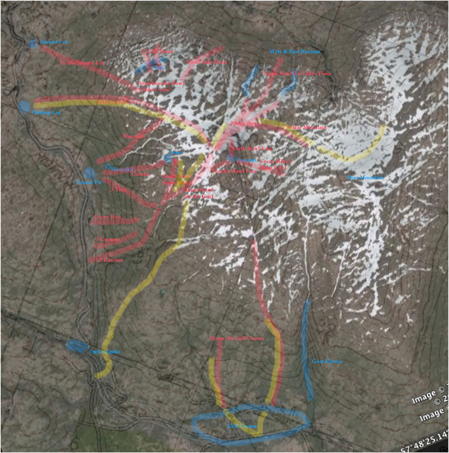 |
|
|
|
Post by patrick on Apr 29, 2009 7:26:14 GMT -9
Looking at the post I just noticed that the map on our blog is much higher resolution - this makes reading the writing a lot easier.
Patrick
|
|
|
|
Post by Philip on Apr 29, 2009 7:52:53 GMT -9
Here's a cartoon version. ;D 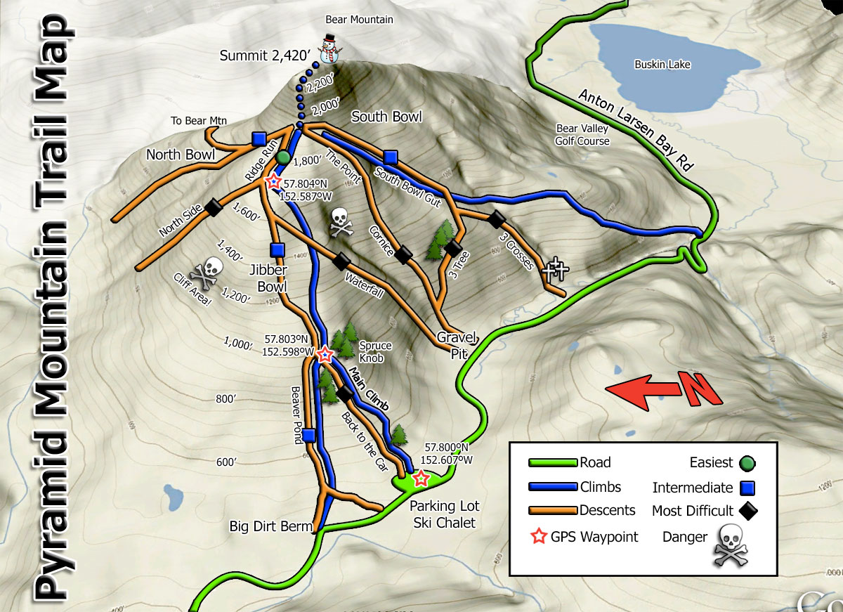 |
|
|
|
Post by Philip on Apr 29, 2009 11:36:09 GMT -9
Ok, I substituted a bigger one in Patrick's post.
|
|
|
|
Post by mrsquishy on Apr 29, 2009 16:15:22 GMT -9
Patrick,
thanks for the great map! Where's the bunny hill?
ms
|
|
|
|
Post by Philip on Apr 29, 2009 17:49:26 GMT -9
Here's a classic Ski Trail Map view: 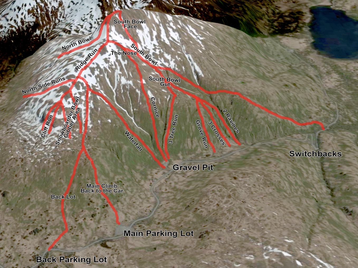 |
|
|
|
Post by patrick on Apr 30, 2009 6:42:11 GMT -9
Wow - those are awesome! Zoya says she likes it because she always wonders what part of the mountain we're talking about when discussing skiing.
Patrick
|
|
|
|
Post by Philip on Apr 30, 2009 9:36:44 GMT -9
It's pretty easy with Google Earth. You can overlay any tiff or jpeg image (map, satellite, images of your kids, whatever) and geo-rectify it by stretching, rotating, etc, to fit the underlying terrain features, and it will "stick" to the topography when you change the view angle. I darkened the background mountains to make Pyramid pop and added the runs and names with Photoshop.
|
|
john
Freshman

Posts: 8
|
Post by john on May 28, 2009 23:12:51 GMT -9
I hope I'm not crashing the Patrick and Philip party, but I've got just a few comments. First, good work guys on putting these maps together. Have any standard names arisen for the golf course slopes? The one that O'Brien regularly skied, I'd like to name O'Brien's Run in his honor.
Also, I believe the South Bowl Gut is higher up than is shown on the last of these maps. These maps seem to label the plateau above 3-Tree as the gut.
Another addition needed is Skid Row, a couloir on the south side that Why?Freeheel and I were able to ski in Feb. How can I show you where it goes?
|
|
|
|
Post by patrick on May 30, 2009 11:59:11 GMT -9
John - we'll do a new map before the start of next season and add all the corrections then. I also think we should do a map with all the local names of mountains and good runs on other mountains. And I think I know where skid row is - is it the run on the far right of the south face - beyond the summit actually towards the golf course? That's the one that John Barklow did with his friend who dropped of the cornice at high speed and released from both of his bindings!
Patrick
|
|
|
|
Post by wyfreeheeler on May 30, 2009 21:17:58 GMT -9
|
|
|
|
Post by patrick on May 31, 2009 14:03:10 GMT -9
I like all the names - they are pretty descriptive which means they'll probably stick. Ever try the second peak of Barometer? The best run is at the far end and goes towards the switchbacks and has a huge rock in the middle - I say call it the 'rock run'. I don't think anyone has named anything else on Barometer. John Barklow climbed it to the cross and might have had a name for the climb. Lots of other mountains have local names and runs. We'll have to start a map. Or maybe a series of topo maps.
Patrick
|
|
|
|
Post by patrick on Feb 20, 2010 18:15:57 GMT -9
I like it! Only thing I might add is the triple black diamond cliff runs around the '1200' foot marker writing to the left of the gibber area. They are also something to be aware of when you are descending in a white out! Patrick
|
|
|
|
Post by Philip on Feb 20, 2010 18:42:29 GMT -9
Good point. I think I would sooner indicate danger areas rather than show it as a "run" for mere mortals.  |
|
|
|
Post by patrick on Feb 20, 2010 20:08:47 GMT -9
Good idea! And put the ravine between the way up and the cornice run as dangerous too. (but a great run when the conditions are ripe and the vis good). Patrick
|
|
|
|
Post by patrick on Feb 21, 2010 8:29:02 GMT -9
That looks good (I like that it is simple), and I think it is a good idea to put those 2 danger areas on the map. To be honest those 2 areas are FAR more dangerous than the risk of avalanches. Now can you post this map all on its own so that you do not have to dig to find it? Patrick
|
|
|
|
Post by Philip on Feb 21, 2010 9:44:45 GMT -9
I modified my first post in this thread and dropped it in there so now it's near the top.
|
|
|
|
Post by kayakhans on May 3, 2010 0:20:35 GMT -9
I am a latecomer to looking at these maps and my skills and stamina will not permit me to try many of these runs. But as a map aficionado I appreciate Philip's "cartoon" display and 3D maps of the Pyramid runs.
Some of the annotated pictures posted by wyfreeheeler confuse me: Isn't the area labeled as EAST FACE actually the Northface of Barometer, facing the Buskin Lake?
Hans
|
|
snowhippie
Freshman
shreddin' the internet
Posts: 21
|
Post by snowhippie on May 3, 2010 11:40:53 GMT -9
Nice job guys, this is getting me so stoked to get there next week and ski...
|
|
|
|
Post by dadoffour on May 3, 2010 14:32:06 GMT -9
@ Snowhippie:
Where are you coming from?
|
|
|
|
Post by Philip on Apr 15, 2012 17:36:17 GMT -9
Two new maps. The original images are courtesy of Phil Z. Soon Steve will have nice waterproof versions similar to these available at Orion's Mountain Sports (1247 Mill Bay Rd).   |
|